Village centre to Bramdean Common
About 4.5 miles
A circular walk with no stiles. It includes a short stretch of St Swithun’s Way and a glimpse of the Church in the Wood in Bramdean Common. Park Lane is so named because it led to Sutton Park, a hunting park for the Bishop of Winchester.
Digital map with points of interest
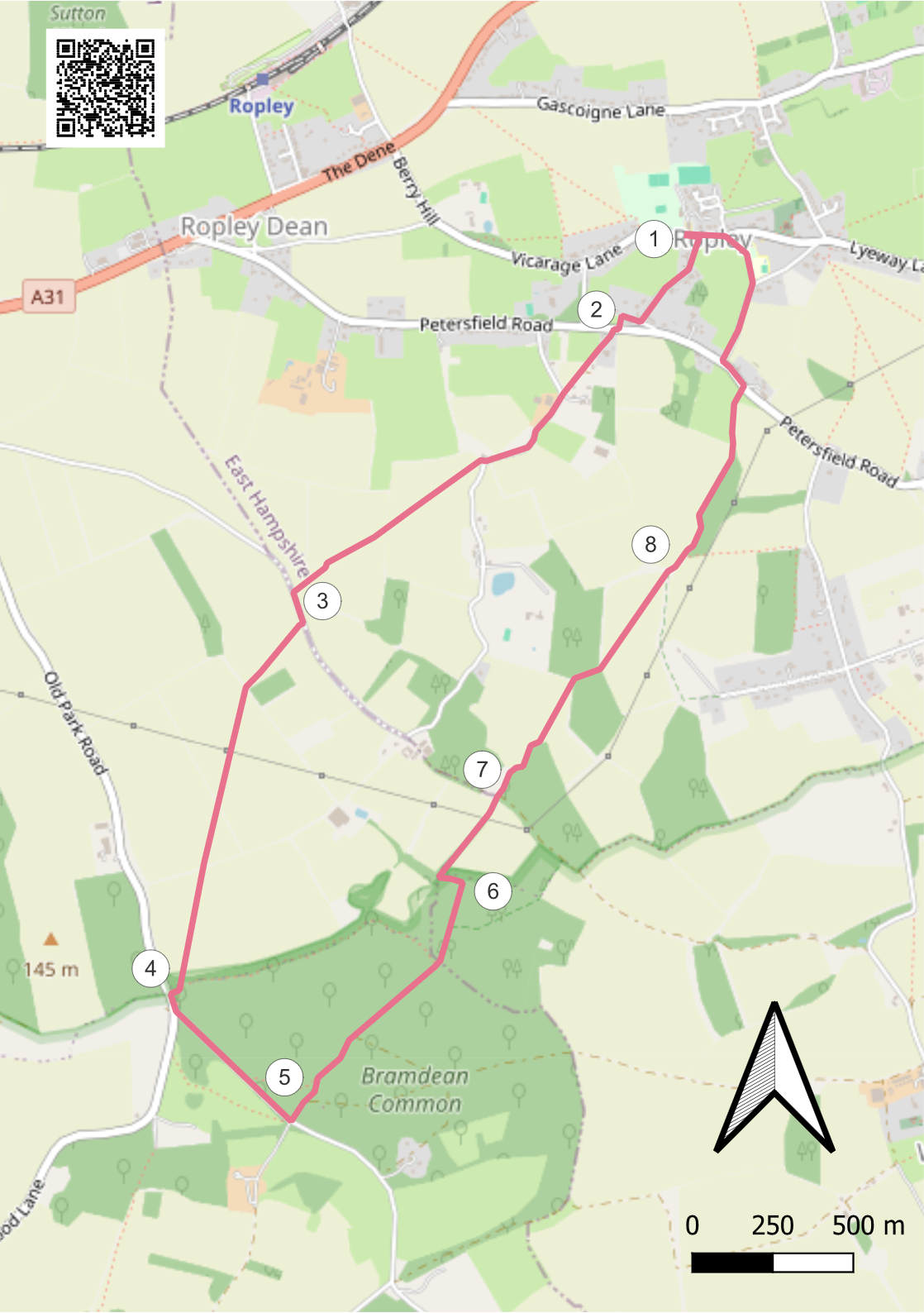
- Turn left out of the Parish Hall car park, and cross Vicarage Lane to Hammonds Lane on your right. At the end of the lane, turn right by The Nook and after 65m, left onto a footpath marked with a green arrow on a pole slightly beyond the turn off, onto Petersfield Road (beware fast traffic).
- Cross, turn right then quickly left, diagonally across a concrete apron to a footpath with two hedges that lies between Burmah Cottage and Fairholme. This path joins a gravel drive, which follows on through onto Park Lane. Turn left, follow the road 340m to the footpath on the right of Hebden House. Go through the gap and cross the field, aiming diagonally left slightly to the right of the power pole. The path will guide you to the next field boundary. Follow the path aiming diagonally left across the field and towards the next hedge. Finally, aim Southwest for a gap by a beech tree in a hedge and a just-visible finger post, and you are on the tarmac of Parkside Lane.
- Turn left onto Parkside Lane, and after 175m, turn right by a gap next to a metal gate into a field as you leave the Ropley parish. Aim for trees on the left on the skyline, climbing and crossing into the next field at the crest of the hill. Aim to the left of the central pylon, following the path across a wooded hedge into the next field. Aim for the corner and a gap passing into a wood. Join a well-worn footpath, avoiding a left-hand path, and arrive on a road next to Bramdean Common.
- Follow the road to the left for 20m and turn left along a road signposted to ‘West Meon’, ‘Petersfield’ and ‘Woodlands’. 480m along this road, opposite a road junction on the right look for a Bridleway sign.
- Turn left onto a footpath through thickets, glimpsing the delightful ‘Church in the Woods’ (also known as ‘The Gypsy Church’) on your right. Merge with a small track from the right, and at a small junction of paths, keep right and pick up the bridleway running due East for 700m until you reach a T-junction. Route finding is tricky in this relatively featureless part of the woods, but the general trend of your route is more or less straight ahead until you come to the T-junction. Don’t be tempted to take any of the several tracks that cross your path at near right angles.
- Bear left at the T-junction and follow the path for a couple of hundred yards and then slightly right through the remains of a gateway onto a path at the edge of the wood. Follow this charming path between two fields to its junction with an obvious track, which brings you back into Ropley parish.
- Go straight across the track onto the footpath opposite, which is flanked by barbed wire fences. In a couple of hundred metres, go through a wooden gate and reach the corner of the wood bearing right over an open field to another wooded corner (the path is usually fairly obvious). Take the track slightly right through a small wood and into a large field. Aim for the far left-hand corner, crossing the field going downhill and through a new wooden kissing gate onto Webb Lane.
- Turn left and follow the lane 620m to join Petersfield Road (fast traffic) at Cowgrove Farm. Turn left and 100m along the road turn right up Church Lane, forking left into School Lane and with Ropley School on your right, reach Vicarage Lane. Turn left past The Forge and the Parish Hall is regained on your right.